
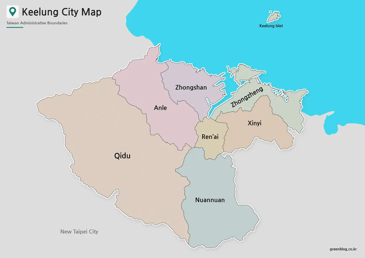
Keelung, situated on northeastern Taiwan's coast, is a compact harbor city defined by steep hills and narrow valleys that carve its urban landscape into seven distinct administrative districts. Surrounded by New Taipei City on three sides, the city's geography creates a unique visual divide between the eastern and western sectors, making a detailed map essential for understanding its structure beyond simple location markers.
Geographic Structure and Administrative Divisions
The city covers approximately 132.76 square kilometers with a population of roughly 360,000, where development is concentrated around the harbor and coastal corridors due to its hilly terrain. Keelung is officially divided into seven districts: Zhongzheng, Xinyi, Ren'ai, Zhongshan, Anle, Nuannuan, and Qidu. Qidu represents the largest area, extending across the southwestern portion of the city, while Ren'ai is notably smaller and occupies part of the central harbor region. Zhongzheng and Zhongshan flank the port on opposite sides, whereas Xinyi and Ren'ai form a compact urban core. Nuannuan and Anle serve as connectors between the center and the broader inland or western edges. The city's layout features a clear east-west division created by the harbor, contrasting the small central districts with the expansive outer areas.
Special Features and Regional Context
Keelung opens toward the sea in the north but is enclosed by mountainous terrain elsewhere, influencing how its districts meet. Zhongzheng District includes both Heping Island and Keelung Islet, which lies north of the mainland and belongs administratively to this district rather than forming a separate administrative area. While more distant offshore islands like Pengjia, Mianhua, and Huaping exist, they are excluded from the primary city map to maintain readable labels for the seven mainland districts. New Taipei City borders Keelung on nearly every landward side, with Ruifang located to the east and other districts connecting in the south and west. This arrangement positions Keelung as a port city fitting within the wider Taipei metropolitan region, offering a clear reference for how the harbor divides the urban center without including roads or tourist attractions.


0 댓글